HIGHWAY 3 AND HIGHWAY 41 – PASSING LANES STUDY
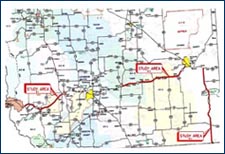 ARA completed a Passing Lane Study for the two lane undivided sections of Hwy 3 and Hwy 41. This study was divided into 3 areas, Area 1 - 72.360 km of Hwy 3 from Hwy 507 to Fort MacLeod; Area 2 - 106.470 km of Hwy 3 from Taber to Medicine Hat; and Area 3 - 113.700 km of Hwy 41 from the U.S Border to Hwy 1. The study included the recommendations regarding the upgrade work for passing lanes on Hwy 3, alternate measures for passing lanes where passing lanes are not feasible due to site constraints and construction of South Bound left turn lane for SB tourist traffic entering Park on Hwy 41:03 at entrance to Cypress Hills Provincial Park. The objectives of the study were to review all existing passing lanes within the 3 study areas for compliance to current AIT standards regarding signing, highway geometrics and operational characteristics and provide recommendations and identify locations for potential new passing lanes within the 3 study areas in an effort to increase passing opportunities and to improve traffic safety and operations for existing and future traffic.
FREEWAY CORRIDOR MANAGEMENT STUDY
HIGHWAY 1 FROM THE BANFF NATIONAL PARK GATE TO THE INTERCHANGE OF STONEY TRAIL
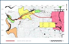 ARA completed a Freeway Corridor Management Study for Highway 1, also known as the Trans Canada Highway, from the Banff National Park gate to the Interchange of Stoney Trail within the City of Calgary Corporate Limits for a total length of 95.05 km. For ultimate freeway status, access to this highway will be restricted to existing and future interchange locations. Existing at grade access and intersections will be retained as long as they do not create operational or safety problems or until such time as full freeway standards are required. The objectives of the study were to identify existing and potential future interchange locations along the highway corridor and identify areas such as bypasses, etc, that need more detailed analysis.
TWO LANE HIGHWAY ROADSIDE TURNOUTS – SITE EVALUATION
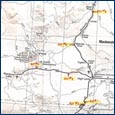 ARA completed a site evaluation study for six roadside turnouts along Highway 35 and Highway 58. After completion of this study recommendations were made for the exact location of roadside turnouts based on the established site evaluation criteria.
TOP OF PAGE
HWY 33:06 UPGRADES THROUGH THE TOWN OF BARRHEAD, AB
 This project involved improvements on Hwy 33:06 from Paddle River to Highway 18 North (km 10.28 to km 14.85) including installation of highway lighting and the expansion, replacement and rehabilitation of the existing water distribution, sewage collection and drainage systems. Upgrading of the highway was through the commercial zoning area of the Town of Barrhead and impacted numerous organizations, businesses and residences; requiring lengthy negotiations, Open Houses
and meetings to achieve and maintain alignment of the stakeholders. In addition, the project involved a variety of underground and overhead utilities, erosion control concerns at the Paddle River, and staged construction to permit traffic accommodation that ensured safety of the traveling public and minimum impact to the affected businesses. A supplemental Functional Plan of Highway 33 was completed by ARA after consulting all stakeholders. Engineering services provided by ARA included Planning, Preliminary Engineering, Design, Tender, Contract Administration and Construction Supervision.
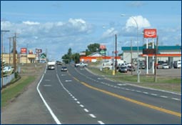
HIGHWAY 62:02 THROUGH THE TOWN OF MAGRATH, AB
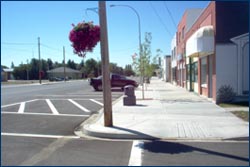 The rehabilitation of this 2km section of Highway 62 through the Town of Magrath from Pothole Creek to Jct. Hwy 5 marked the first significant work to be done to this section of highway in 26 years. The rehabilitation work included substantial sanitary sewer, storm sewer and water main construction (the complexity of which was compounded by the presence of a multitude of existing buried utilities for which there were no accurate records); construction of a storm water retention pond; utility adjustment work to streetlights, power poles, gas/water/telephone services; intersection reconfiguration; grading; granular base course; concrete curb and gutter and sidewalk; and asphalt concrete pavement. Engineering services provided by ARA included Preliminary Engineering, Detailed Design, Tender Preparation, Construction Supervision, Contract Administration, and Warranty Inspection. The project involved extensive interaction by ARA with Town Council, residents and businesses during Design and Construction to minimize inconveniences incurred by the traveling public and the local businesses as a result of construction activities and traffic detours.
DEERFOOT MEADOWS INTERCHANGE
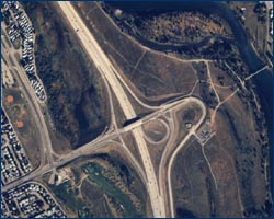 The Deerfoot Meadows interchange was the first infrastructure project located on a major freeway in Calgary, Alberta where interaction between Alberta Transportation and a Developer was required. ARA Engineering Ltd. was retained by a private land developer to provide engineering services for the planning, design and contract administration of the complete interchange including all ramps and roadways, bridges and overhead sign structures. As the interchange lead, the project required significant management and co-ordination of both in-house personnel and sub-consultants retained by ARA. Engineering services provided by ARA included the Project Management, Functional Planning, Detailed Design, Sole Sourced Tender Preparation, quality assurance testing, Construction Supervision and Contract Administration. ARA further provided quality assurance testing on the adjacent Deerfoot Meadows land development site.
HIGHWAY 2:18 & :20 NORTH of CROSSFIELD to NORTH of ACME ROAD INTERCHANGE
 Grading, Granular Base Course and Asphalt Concrete Paving
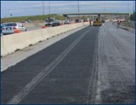
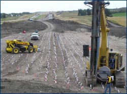
The project on Hwy 2:18 from km 23.130 to km 29.570 (NBL & SBL) and Hwy 2:20 from km 0.000 to km 4.858 (NBL & SBL) consists of widening the median of the existing twinned highway and constructing the embankment for the future 6 lanes. Highway 2 is a major link in Alberta’s North South Trade Corridor with approximately 25,000 vehicles traveling in each direction of the highway daily; approximately 14% of which consists of truck traffic. The services to be provided by ARA include Preliminary Engineering, Detailed Design, Tender Package Preparation, Construction Supervision and Contract Administration for Grading, Granular Base Course, Asphalt Concrete and other work.
HIGHWAY 43:16 & :18 FROM EAST of GREENCOURT to WEST of SANGUDO
Grading, Granular Base Course and ACP
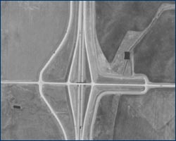
The latest work on Hwy 43 undertaken by ARA is the twinning of 18.44 km of Hwy 43:16 & :18 from East of Green Court to West of Sangudo. Engineering services provided by the company included Preliminary Engineering, Detailed Design, Tender Preparation, Contract Administration, Construction Super-vision and Post Construction for grading, granular base course and asphalt concrete paving. Embankment stability and the necessity of slide repairs is a key issue associated with the project. Over the past several years, ARA has completed approximately 125 km of twinning work on Highway 43 including Hwy 43:04 from West of Kleskun Hills to West of Bezanson and from West of Bezanson to East of Smoky River; Hwy 43:06 from Sturgeon Lake IR East Boundary to Valleyview East Corporate Limit; and the Hwy 43 and Hwy 2 Interchange at the Jct. of Hwy 43:04 and Hwy 43:03/2:72.
DETAILED TRAFFIC CONTROL REVIEW IN EDSON
HIGHWAY 16, FROM THE RAILWAY OVERPASS TO 70TH STREET
 ARA conducted a Detailed Traffic Control Review of Highway 16, also known as the Yellowhead Highway, couplet between the railway overpass and 70th Street through the Town of Edson. The Town has designated westbound lanes of Highway 16 as 4th Avenue and eastbound lanes as 2nd Avenue, within town limits. The Town’s major Arterial Streets intersect the Highway at grade at different intersections and the Highway 16 provides direct access to abutting properties. The study area for the project included a review of the functionality, safety and operational aspects of the intersections, existing parking control, pavement markings, signage, speed zoning, and pedestrian accommodations on Highway 16 passing through the Town Of Edson.